TerraCube X3
360-Perception Sensor Block
The all-seeing companion to our S-series science cube—an 80 mm edge, 150-gram powerhouse that fuses imaging, ranging, acoustic, and micro-meteorological sensing into one ultra-rugged enclosure. Whether perched on a lunar lander leg, riding shotgun on an AUV, or bolted to the mast of a Mars rover.
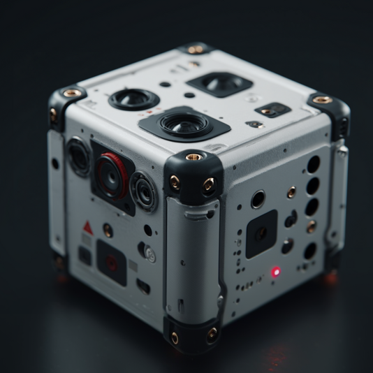
Integrated Payload Suite
| Domain | Built-in Technology | Core Specs |
|---|---|---|
| 360° Visual Imaging | Quad f/2.0 14 MP global-shutter cameras (RGB + NIR) | 6K panoramic stills • 4K video @ 90 fps |
| Active Depth/Ranging | Solid-state beam-steering LiDAR, class 1 eye-safe | 0.02 m precision • 0.8–120 m range |
| Thermal Vision | 640 × 512 px uncooled LWIR core | –40 … +300 °C mapping |
| Acoustic / Ultrasound | 8-element MEMS array | 20 Hz–60 kHz • sound-source localisation |
| Micro-Met Station | 7-DOF IMU + tri-axis magnetometer + nano-barometer + humidity + dust particle counter | Attitude ±0.01 °, pressure ±0.05 hPa, PM2.5/10 logging |
| Edge Compute | 16-TOPS dual TPU with 3 GB LPDDR4 | On-device SLAM, object/terrain segmentation |
Stand-Out Advantages
Full-Sphere Awareness
Four synchronised sensors stitch a true 360 × 180° panorama while on-board SLAM fuses LiDAR depth for dense point-cloud generation in real time.
Radiation-Tolerant AI
Dual redundant TPUs, ECC RAM and watchdog micro-kernel keep inference running after high-LET events (>25 krad TID).
Smart Power Budget
Duty-cycled sensor clusters, adaptive FPS, and wake-on-event cut draw to 1.1 W average (sleep <70 mW).
Field-Swappable Corners
Corner bumpers house antennae & heat pipes; swap for high-gain radios, extra heatsinks, or mission-specific anchor lugs without opening the chassis.
Single-Cable Integration
15-pin rugged "Data-Power-Sync" (DPS) interface combines 48 V PoE++, GigE Vision, and PPS timing for plug-and-survey installs.
Technical Snapshot
Physical
Survivability
Interfaces
Power
Reliability
Software
Mission Profiles
Hazard Detection
Combine wide-angle LiDAR with stereo vision to classify sand traps, craters, or ice layers in milliseconds.
Sub-Ice Lake Mapping
Attach to ROVs to image crevasse walls in LWIR while acoustic array measures cavitation and crack propagation.
Volcanic Monitoring
Capture simultaneous thermal gradients, gas plume particle size, and infrasonic tremor data without human exposure.
Space-Dock Approach
Deliver zero-lag, full-sphere situational awareness to robotic arm controllers during capture operations.